Seasonal Climate Update, February 5, 2013
Issued: February 5, 2013
Rainfall
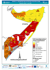
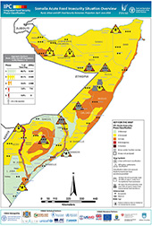
Deyr 2012 rains started as early as in the third dekad of September in most of central and southern regions. The rains advanced to the rest of the areas in October. FSNAU field reports indicated average to above average rains in all livelihoods of Bari, Hiran, Middle Shabelle, Bay and Bakool. Nevertheless, depressed rains were reported in north of Gedo, coastal areas of Lower Shabelle and Lower Juba and parts of Guban, Sool plateau and Nugal valley livelihoods.
In October and November, river flooding mainly caused by deposition of alluvial soils and man-made diversion of water was reported in Beletwein (Hiran) and Kurtunwarey (Lower Shabelle). River levels increased steadily in October in the lower reaches of Shabelle attaining moderate flood risk levels, but stabilized in November and December. Flash floods occurred in October - November in small areas in Bay and Hiran. Flash flooding during the month of November hampered transportation from Mogadishu to Hiran region.
Satellite derived rainfall estimates (% of normal) from TAMSAT (Tropical Applications of Meteorology using Satellite) portray rainfall deficit in Awdal, most of W. Galbeed, North Mudug and most of Sanaag and small areas of Bay, Bakool and the Jubas.
Normalized Difference Vegetation Index (NDVI)
2012 Deyr rainfall impact on biomass according to the Normalized Difference Vegetation Index (SPOTVEGETATION-1Km resolution) for December, 2012 (Dekad-3) show generally normal to above normal vegetation conditions. Poor vegetation conditions are visible in north of Gedo, in large areas of Lower Juba and in small parts of Awdal, Sanaag, Bay and Bakool regions.