Products / Maps
Maps
FSNAU’s Geographic Information Systems team provides support in the area of spatial analysis and cartography for Somalia. The team utilises a number of GIS and remote sensing applications for decision support and early warning with the aim of translating complex food security and humanitarian information into simple maps that can be used for decision making.
The team also, on request provides strategic consulting assistance to donors, policy makers and partner agencies working in Somalia on issues related to mapping and analysis of various indicators to support humanitarian work in the country.
Over the years, the team has continuously produced maps, data sets, and analysis of relevant spatial datasets and these are included in our online catalogue. These are broadly categorized into:-
- Agriculture Maps
These maps based on FSNAU data indicate seasonal (Gu and Deyr) production and comparative statistics for past production trends (post war average, previous season etc). - Markets Maps
FSNAU and FEWS/NET monitors 44 markets across Somalia including the major cereal and livestock markets. The following maps relate to the monitored markets: - Livestock Maps
Maps indicating migration patterns are based on 'normal' migration vs. observed - Nutrition Maps
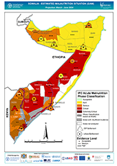
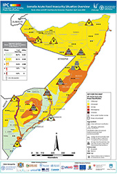
FSNAU produces maps highlighting the areas of concern based on the nutritional situation, trends, as well as maps indicating nutrition survey sites since 1999. These maps show the trend in malnutrition, provide an update on the current situation and indicate locations of reporting health facilities. - Integrated Phase Classification Maps
FSNAU has developed a standardized classification mechanism to enable a stronger linkage between information and response. The Integrated Food Security and Humanitarian Phase Classification map is included here. It consists of criteria to integrate multiple facets of food and livelihood security information into a simple statement indicating levels of severity and general implications for humanitarian response. This information is mapped seasonally, in a consistent manner indicating geographic areas of concern, levels of severity, a causal summary, and projected trend. - FSNAU Livelihoods Zones, Management Areas, and Somali Livelihood Indicator Monitoring Maps
FSNAU utilizes a livelihoods approach to food security analysis which categorizes geographic areas based on livelihoods. Included below are also maps on FSNAU's field level management structure and nodes for data collection and the Somali Livelihood Indicator Monitoring System (SLIMS) town locations. - Administrative Maps
These are maps that indicate administrative boundaries in Somalia. - Conflict Maps
- GIS Maps / Shapefiles
This link contains GIS shapefiles and related Geo-referecenced background IPC images. - Other Maps
These include maps either produced by FSNAU or made available here for the benefit of the community. Also included are general geographic maps on demography, education, and displacement. Some maps are based upon data from partners organizations. Non-FSNAU based maps include source information within the legend.
Some of the other maps that FSNAU avails include:-
Disclaimer: Note that the boundaries and names on these maps do not imply official endorsement or acceptance by the United Nations. The regional and district boundaries reflect those endorsed by the Government of the Republic of Somalia in 1986.